|

 |
Weather.com
Snowy Midwest Through Sunday
Spring has arrived, but Winter Storm Virgil will make it feel like we
are in the heart of winter for millions from the Midwest to the
Mid-Atlantic through this weekend and into Monday.
Virgil has delivered around 8 inches of snow to Denver and 14 inches of
snow to Goodland, Kan. as of early Saturday afternoon. Snow and gusty
winds forced the closure of I-70 in eastern Colorado Saturday morning.
We expect a swath of significant snowfall and increasing winds to now
head from Kansas and Nebraska to southern Iowa, Missouri, Illinois,
Indiana and Ohio Saturday night through Sunday. Lighter snows will
linger into Monday across the Ohio Valley.
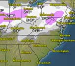
Snow accumulations of 4 to 10 inches are likely near and either side of
the I-70 corridor as shown on our snowfall forecast graphic. This
includes cities such as Kansas City, St. Louis, Springfield, Ill.,
Indianapolis and Columbus, Ohio.
At this time, it appears the heaviest snow will stay south of Chicago, although some minor accumulations are possible.
Locations where snow falls at night and where snowfall rates are
heaviest in the daytime will have the greatest chance at seeing
snow-covered roads and poor travel conditions even with the higher sun
angle in late March.
In Virgil's warm sector, we'll be watching parts of the South for a
threat of severe storms capable of producing tornadoes Saturday night
through Sunday. For more information on this threat, click here.
Virgil will head east into the Mid-Atlantic and Northeast Sunday evening into Monday...
Read the complete article with links and video at Weather.com
|
|
|
|